Cao Bang is a province in Northeast Vietnam. The province shares border with Tuyen Quang and Ha Giang in the west, Bac Kan and Lang Son in the south. It also has common international border with Guangxi Province of the People's Republic of China.
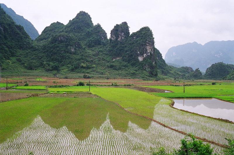
Cao Bang is situated in Northeast Vietnam. The north and northeast border Guangxi province (China) with the boundary of 333.403km long. Cao Bang province has borders with Ha Giang, Tuyen Quang, Bac Kan, Lang Son provinces within Vietnam. North-South direction is 80 km, from 23°07'12 "- 22°21'21" north latitude (from Trong Con commune, Thach An district to Duc Hanh commune, Bao Lam district). East - West direction is 170km, from 105°16'15" - 106°50'25" east longitude (from Quang Lam commune, Bao Lam district to Ly Quoc commune, Ha Lang District).
Cao Bang has the natural area of 6.690,72km², is the limestone and earth plateau with the average altitude of over 200m, the boundary area has the altitude from 600 to 1300m above the sea level. Forest accounts for more than 90% of the provincial area. The province is divided into 3 distinct areas: the eastern area with many rock mountains, the western area with limestone and mountains, and the southwestern area with earth mountains and dense forests. There are two large rivers, namely Gam River in the west and Bang River in the center and the east flowing through the province. In addition, there are some other rivers as Quay Son, Bac Vong, Nho Que, Nang river or Hien river.
Cao Bang climate characterizes the temperate climate. Summer here is hot and humid, the average high temperature is from 30 - 32°C and the average low temperature if from 23 - 25°C, and the temperature does not exceed 39 – 40°C. In winter, due to the Cao Bang topography welcoming winds so it is similar to the type of temperate climate, the average low temperature is from 5-8°C and the average high temperature is 15 - 28°C. The fall and spring is not clear, the irregular weather; spring is usually monsoon weather and autumn is cool and pleasant.
Cao Bang and Lang Son provinces were known as chau Quang Nguyen during the time of Ly - Tran Dynasty. Quang Nguyen (Lang Son and Cao Bang) official became a part of Dai Viet in 1039, under the reign of King Ly Thai Tong when he expelled Nung Tri Cao. After the fall in Thang Long in 1592, Mac Dynasty run to Cao Bang and built this land to fight the Le - Trinh until 1677.
On December 27th, 1975, Cao Bang was merged with Lang Son province into Cao Lang province. On December 29, 1978 Cao Bang was reestablished from Cao Lang province, and two districts of Ngan Son and Cho Ra of Bac Thai province were merged into Cao Bang province according to the Resolution of the 4th session of the National Assembly VI. At that time, Cao Bang was divided into Cao Bang town and 11 districts.
According to the population census in 2009, the population of Cao Bang is 507,183 people. The typical ethnic groups in Cao Bang include Tay, Nung, Dao, San Chi, Kinh, Mong and Hoa. Among them, Tay ethnic people cover the majority of Cao Bang population (about 42%), Nung (35%), the rest are other ethnic groups such as Dao (9.8%), Hmong (6.3%), Kinh (5.5%)... Notably, most of ethnic groups in Cao Bang maintained their own language and have so far used in their daily life. Vietnamese today is the common language in Cao Bang, which almost people here can understand and communicate.
Cao Bang consists of 1 city and 12 districts: Cao Bang city, Bao Lac district, Bao Lam district, Ha Lang district, Ha Quang district, Hoa An district, Nguyen Binh district, Phuc Hoa district, Quang Uyen district, Thach An district, Thong Nong district, Tra Linh district, Trung Khanh district.
According to sources of the Department of Education - Training in Cao Bang province, until December 31st, 2011, the province had almost 90,000 students of all levels, with 365 schools (from primary to high school ), and 7790 teachers. For the professional education, the province had 3 high schools, with 115 teachers and 3500 students; a college, with 88 faculty members, and nearly 2,000 annual students; and a vocational school, with more than 800 students every year. Also the province pays attention to improve the human resource qualifications, skills for the construction and development of provincial socio-economy.
By 2012, the province has 312 health facilities, including 16 hospitals, 96 regional clinics, a nursing station, 199 remote health clinics and wards; including 2339 officers, including 514 doctors, 906 nurses and technicians, 556 nurses. The core orientation of the health care sector is care for people, especially mothers and children in remote areas and borders; focuses on building and improving the health care capacity, preventing some diseases: Malaria, goiter, tuberculosis, tetanus, child malnutrition.
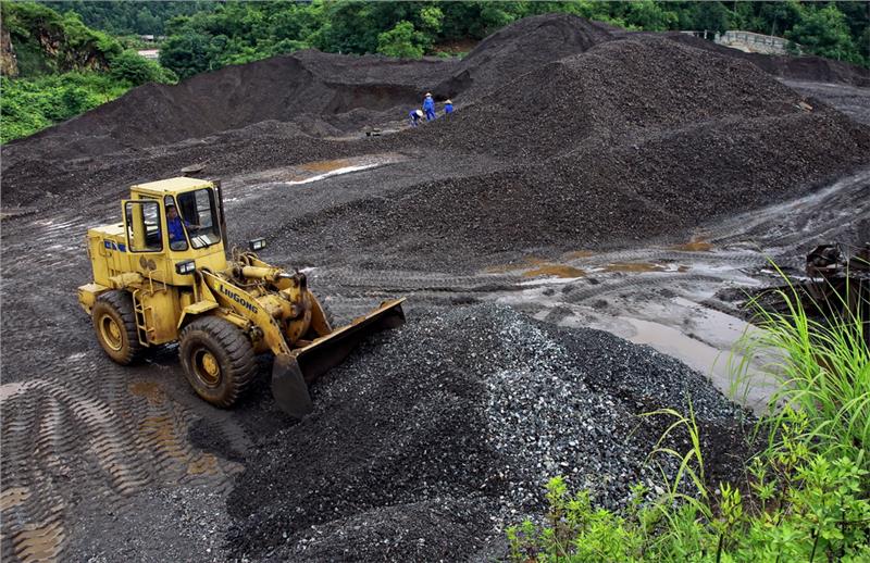
In recent years, Cao Bang economy has many positive changes. In 2009, the provincial revenue was only about 390 billion dong; in 2013, this number increased to 1.126 billion dong. Though the year of 2014 had many fluctuations, the provincial revenue reached 1.230 billion dong, in which revenue from customs and border fee reached nearly 400 billion dong.
In 2015, Cao Bang will focus on 3 key fields: Develop agriculture towards the modernization and industrialization. Utilize natural resources for industrial development mining, mineral processing, wood processing, medicine... Develop commercial services, imports and exports and tourism. In particular, Cao Bang prioritizes to boost border trade cooperation, border economic development.
Cao Bang has over 330 kilometers of border with an international border gates, 3 national border gates and many trails. Cao Bang borders Bach Sac city, connects Trung Khanh city - one of large 4 industrial centers of China with the import and export value amounted to 60 - 70 billion USD. On the other hand, Trung Khanh is also a transit point for 6 southwestern provinces of China to Beijing, Dalian, and Shanghai... The goal or province is to turn Cao Bang large into the large logistics service center connecting between Vietnam and ASEAN with 6 southwestern provinces of China.
Tourism development has helped to increase the proportion of service sector GDP of the province. In addition, the tourism development contributes to increasing the proportion of service sector and creating jobs for more than 1,500 labors, income and local living standard, improving the development of other industries, restoring many traditional festivals and crafts, raising awareness and responsibility of the state agencies and local communities in the preservation and development of tangible and intangible cultural heritage.
Cao Bang is famous for not only the white rice and clear waters, but also a vibrant culture with the cultural intersection of many ethnic groups. Each ethnic group has its own unique traditional cultural heritage. Tay people occupy relatively large number in Cao Bang. Cultural identities of Tay people is expressed folk singings and dances as Luon singing, Then singing, Luon Shuong, Luon Coi, Luon Ngan, Shuong dance, chau dance, dan tinh, Phuong ly. Nung ethnic people have many branches, based on the dress and the voice to distinguish: Nung Inh, Nung An, Nung Loi, Nung Giang, etc. Costumes of Nung people are richer because Nung ethnic group has many branches but their basic features are the same. Nung people are known for mua quat (dance with fan), mua khan (dance with scarf), dan nhi and tambourine, Da Hai singing - a type of old Tuong singing with a 300-year history.
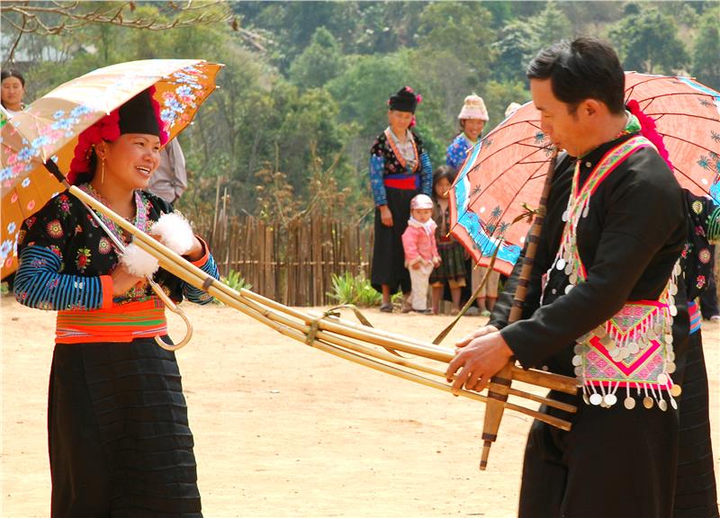
Dao ethnic people in Cao Bang have hard-working nature, living mainly in the low hills. Dao ethnic costumes are excellent and diverse in form. Dao ethnic group in Cao Bang includes 2 branches: Dao Tien and Dao Do (Red Dao). The name Dao Tien appears because they decorate silver coins on their clothes, while Red Yao people use red indigo fabrics to make their traditional costumes. Decorative patterns on the fabric of the Dao are extremely unique, rich, mainly the images commonly seen in daily activities, such as: flowers, plants, ancestors, and animals close to their lives. These images have creates distinctive nuances in Dao ethnic culture. H'Mong people mostly live on the high mountains, remote areas, concentrated in Bao Lac, Ba Be, Thong Nong, and Ha Quang with the nomadic life. H' Mong people are famous for mua o (dance with an umbrella), and khen sound.
Cao Bang, a province in the northern border area of the country, which has proud historical and cultural tradition. The traditional history of Cao Bang associates with Vietnam history from the early days of the building and defending the country.
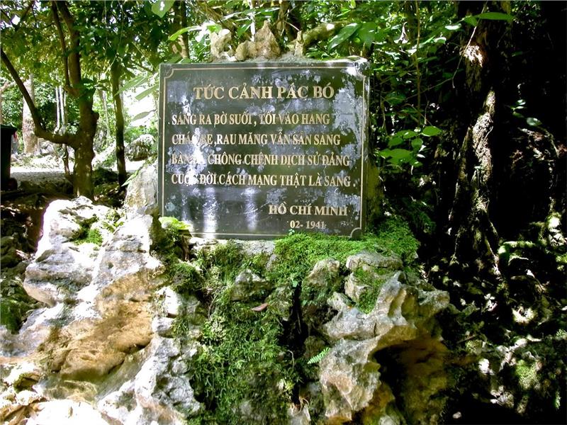
Referring Cao Bang is referring to places marked for a period of epic history Pac Bo, Tran Hung Dao forest, Dong Khe, Lam Son, etc. Coming to Cao Bang is a pilgrimage to the root, is to revisit historical relics, to learn about a heroic history of the nation. Typically, Pac Bo located in Truong Ha commune, Ha Quang district. This is the place where President Ho Chi Minh lived, worked and launched revolutionary movement to gain the independence for the nation from 1941 to 1945. Kim Dong relic includes Kim Dong grave and monument at the foot of a massive mountain range. Tran Hung Dao Forest is the place where Vietnam Propaganda Liberation Army Team was established.
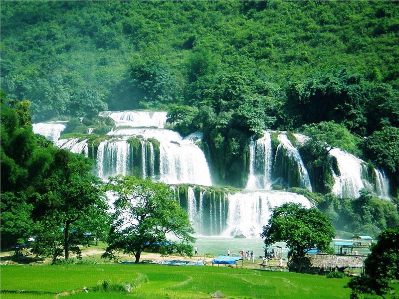
Ban Gioc waterfall is a masterpiece of nature gifted for Cao Bang, seen as one of the most beautiful waterfalls in Vietnam. Located in Dam Thuy commune, Trung Khanh district, about 89km from Cao Bang town, Ban Gioc waterfall originates from the Quay Son River and falls over a height of 53m. At the top, the waterfall is seen in three parts divided by rocks and trees. As the water falls down the cliff and merges with sunlight, a seven-coloured rainbow formation is witnessed. Many green trees and flowers that perfume the air are located at the base of the fall.
Located in the heart of limestone mountains, about 3km from Ban Gioc waterfall, Nguom Ngao is one of the famous caves of Cao Bang formed by the weathering of limestone. With the length of 2144m, Nguom Ngao cave is quite large, consists of 3 gates and has the beautiful scenery like the fairy land. Stalactites grow from everywhere interwoven into a magic complex maze. Nature has cleverly created shapes for inanimate rocks, like people, trees, animals, fairies, and lotus... All cover up a magical space, mingled between rock and water.
Khuoi Lai Lake is located between hillsides in Hoai An district, Cao Bang town. The lake is 72ha wide, clear water and gentle year round. The poetic space of Khuoi Lai Lake is an ideal place for ecotourism, fishing, hunting and boating around the lake. The stunning natural beauty, majestic mountain scenery with many famous historical relics and a variety of cultural activities makes Cao Bang become an attractive tourist destinations of domestic and foreign tourists.
Festival
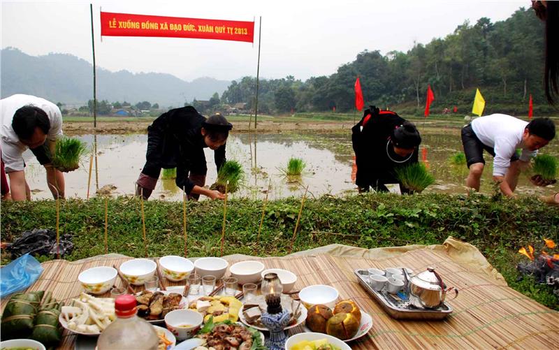
Cao Bang is the province in Northeast Vietnam with immense forests and majestic rivers. The beauty of famous scenic spots and historical relics are the attractive features appealing tourists. Festival is also an intangible cultural heritage bearing the cultural identity of Cao Bang. Each festival has its own features associated with the cultural identity of each locality. For long time, they have become a form of community cultural activities and an indispensable spiritual “food” of local people. There are many large festivals in Cao Bang every year attracting many local people as well as tourists such as Long Tong, Ky Sam Temple, King Le Temple, Da Quan Pagoda, Nang Hai and fireworks festival.
Long Tong is one of the most important festivals of Tay people and Nung people, held from the 4th to 10th day of the first lunar month. This is a festival bearing the stamp of the agricultural production from the opening rites, offerings to folk games in the festival. Long Tong festival has long appeared and passed from generations to generations in ethnic communities of Tay and Nung people in north mountainous region: Thai Nguyen, Cao Bang, Bac Kan, Lang Son and some northwestern provinces.
King Le temple is situated in Den village, Hoang Tung commune, Hoa An district. It was built on a high hill in north of Na Lu citadel under Ly Dynasty (the eleventh century), known as the Long mound (i.e. Dragon mound). King Le temple was ranked the national historical relics in 1995and has become the place to celebrate festivals and cultural activities of local people. People participating in the festivals are to pray for good weather, good harvest, health and express the morality "When drinking water remember its source". Nang Hai is a festival of Tay ethnic people, started in January and lasts to mid March. Nang Hai festival is held with the symbolic significance to welcome Moon Mother and fairies to earth in order to help people in the work and life.
Cao Bang festivals bear deeply humanism, pray for happiness, luck, good crops and prosperity. In addition, there are also festivals honoring the national heroes, festivals showing rituals, customs of the ethnic groups. Moreover, festival is also home to converse and preserve the value of cultural and artistic traditions. Then singing, Sli singing, Phongslu, Da Hai, Ha Leu... with the sweet melodies and folk games is potential for Cao Bang tourism development.
